The Movement of Plates (background reading)
Why does some land in Australia looks very much like land in India?
How can the same kinds of fossil plants be found in Antarctica and also found in Australia, and India, although they are separated by oceans?
 What
if at one time all the landmasses were once joined together? What if land
moved?
What
if at one time all the landmasses were once joined together? What if land
moved?
Alfred Wegener (left), a German meteorologist, described this idea in a book published in 1915. People laughed at him, but we now know that he was on the right track. He based his theory on the evidence of shape, fossils, rock types, patterns of glaciers, and records of climate long ago.
The Earth's surface consists of eight large plates and several small ones, some moving at the speed of a growing fingernail.
Even at that speed continents have moved enormous distances. For example, at one point North America was located near the Equator. You can image how different the climate was for North America then.
The Earth's Engine What force is moving the plates around the globe? Beneath the crusts, the Earth's material is slowly rolling in big patterns of circulating magma "convection patterns." They work on the same principles as boiling water on your stove or big air circulation patterns in our weather.
When matter is hot, it expands, becomes lighter, and rises. As it cools, it contracts, becomes denser, and sinks. As a result, there are places where magma is rising and spreading out and there are other places where magma is sinking. In between, the magma is moving horizontally.
The continents float on this unstable fluid. Sometimes they crash into one another, sometimes they are pulled apart, and sometimes they grind past each other going in different directions.
What are the clues the scientists have used to piece the puzzle together?
1. Rock layers (strata) with certain characteristics (volcanic ash, meteorite dust, glacial tills, changes in sea level, sand sizes, ancient shell beds) can be compared with one another and coordinated.
2. Fossils are the remains and impressions of ancient plants
and animals preserved in layered rock. Fossils of plankton were useful for
reconstructing continental history. Certain animals lived in colonies only
during specific ages of Earth. Their locations can be matched up. For
example, a section of Australia can be matched to a section in India by
matching areas in which these fossil plankton are found.
For
example, fossil records of the leaves of the fern Glossaopteris are found in
South America, India, Africa, Australia, a pattern consistent with an earlier
unified land mass. Fossils of Mesosauris
(a first marine reptile) was found in both South Africa and South America, a
spread consistent with a period of time in which these continents were joined.
In
addition, the bottom three layers of rock in the three continents are
identical; (glacier- influenced;
coal, shale and sandstone with Glossapteris fern fossils; lava flows.
3. Patterns of magnetism.
The final piece of evidence that led to international acceptance of
plate tectonic history came from magnetic data taken in the 1960s. The movement
of the Earth’s liquid outer core generates a magnetic field, and the core
behaves like a magnet. Every half million years the polarity of this magnetic
field changes because the currents in the Earth’s core change. When liquid
magma rises from deep in the Earth and solidifies, the iron within lines up
with the magnetic field]. Essentially, the magnetic field present when the
magma solidifies is frozen into iron-bearing rock.
A spreading ocean. When a scientist went to measure the magnetic
patterns of the Atlantic Ocean, he got astonishing results: the magnetic
patterns on either side of the Atlantic Ridge (out of which new magma was
slowly pouring) were mirror images of each other. The pattern of stripes could
be compared with stripes in known, dated rocks. Each stripe represented sea
floor created while the magnetic field was steady for about a half-million
years. Newer material was closest to the ridge, and older material was located
further away. So the sea floor was obviously spreading apart at a rate of 2 cm
per year, not much in a single year, but considerable over millennia! Long ago this process had split a large
landmass apart and created the Atlantic Ocean. The ocean is still growing, and
poor sea turtles have to swim across it further and further every year to
return to their nesting sites!
When Plates Pull Apart
Where two plates are pulled apart, two things can happen. If the break is in the ocean where the crust is thin, like in the Atlantic, fresh liquid magma oozes out, filling the opening and making a ridge. If the break is caused by magma rising under a continent, the continent can break apart.
First the magma "domes" under the continent, lifting it up. Then erosion extends the gap. There are signs that there was an unsuccessful rift in the Great Lakes area of the United States. A rift is successfully opening on the African continent. Usually the pressure to pull apart reveals itself in a three-armed radiation pattern, where bodies of water are created in the arms as water moves into the rift. Can you see where this is happening near the Horn of Africa?
If a break happens where the crust is thick or no magma is rising, deep trenches can occur. On land, this can cause deep lakes like Lake Baikal that is so deep that it contains 10% of all the Earth's freshwater! If this happens in the ocean, deep underwater trenches are formed such as the Philippine trench that goes further below sea level than Mount Everest is above sea level!
When Plates Meet
When continents encounter each other, several things can happen. The plates can move alongside each other (causing a transform fault), one can slide under the other (creating a subduction zone), or they can move together and effectively jointly create another (forming ridge axes).
When One Plate Slides Beneath Another: subduction
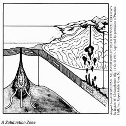 Where
two plates collide, the lighter one rides up on top of the other. This causes
frequent earthquakes as the plates buckle and bend. The lower plate is dragged
down under the upper plate, and some of its material is heated until it becomes
liquid. Most of this liquid is then returned to the Earth's center. This area is called the "subduction
zone." Some of the hot liquid is too light to continue down and melts its
way up through the upper plate and makes volcanoes. All around the Pacific,
continental plates are moving over heavier oceanic plates.
Where
two plates collide, the lighter one rides up on top of the other. This causes
frequent earthquakes as the plates buckle and bend. The lower plate is dragged
down under the upper plate, and some of its material is heated until it becomes
liquid. Most of this liquid is then returned to the Earth's center. This area is called the "subduction
zone." Some of the hot liquid is too light to continue down and melts its
way up through the upper plate and makes volcanoes. All around the Pacific,
continental plates are moving over heavier oceanic plates.
A few miles inland, over the subduction zone, there are often volcanoes: Fuji in Japan and Mt. Saint Helens in the United States are examples. What are other examples? Can you see why the region around the Pacific is called the "Ring of Fire?"
subduction
sub is Latin for "under," ducere is Latin for "to lead]
Adding together: Creating
Mountain Ridges
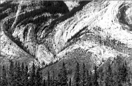
The pushing of plates against each other also creates spectacular mountain folds, even folds that double back upon itself. India was once a separate continent. As its plate moved, India crashed into Asia and the impact has created a huge ridge axis called the Himalayas.
Students might enjoy the following animations:
http://nsdl.org/resource/2200/test.20061004094954194T
Resource: Making Sense with
Plasticene (an example from Pennsylvania.).
http://www.dcnr.state.pa.us/topogeo/classroom/teachers/elem4.aspx
Resources
AMNH Plate tectonics
Plate tectonics http://ology.amnh.org/earth/plates/tour.html